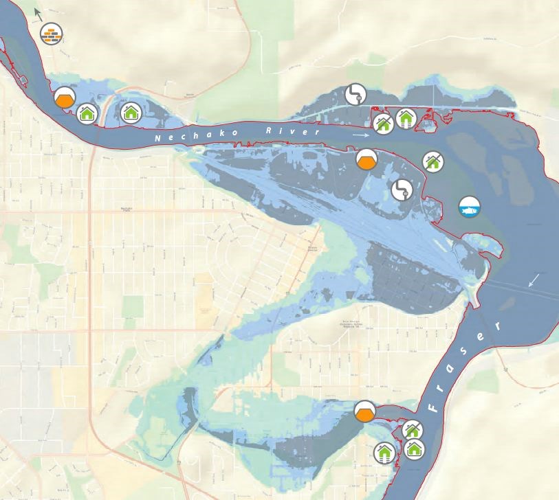
Almost 10 years after back-to-back floods swamped riverfront properties, Prince George is acting on recommendations to review risk areas and come up with community-supported solutions.
In 2007, spring floods threatened low-lying homes along the Fraser River and just months later winter ice-jams raised the Nechako River, burying River Road and other areas in feet of water. At the time, city council called on Northwest Hydraulic Consultants to prepare three reports, which ultimately identified 14 high risk areas - seven on each river.
"The plan, coming out of that was to have flood meetings (with those neighbourhoods) and having project scoping meetings and engagement with the community on reviewing what flood control solutions could be possible for their area," said Dave Dyer, the city's engineering and public works general manager.
Now, with $10,000 in funding from the Local Government Grants Act - and $15,000 from the city - staff and consultants can get started on an investigation looking at flood protection in those key areas.
Vulnerable spots include city wells and pump stations along the Nechako River and Ferrell Street homes near Paddlewheel Park, which border the Fraser River.
"They're so close to the river there really is very little can be done of any kind of infrastructure," said Dyer of those homes. "Decks are literally just right at the banks edge.
"In some cases it's not as severe as being right along the river. They may not know that they're vulnerable," Dyer added.
"When people develop and settle floodplain areas, protection from flooding becomes a necessity," said a 2011 summary by Northwest Hydraulic Consultants (NHC), which received an engineering excellence award from the Consulting Engineers of B.C.
The consultants also noted the two floods "raised questions about the vulnerability of flood prone areas within the city and resulted in calls for long-term solutions to protect properties within the 200-year floodplain."
With several other projects on the go, Dyer expects community consultations will begin in the fall with a report early next year. The low snowpack this year means there's little fear of floods in the short-term.
Much of the work will be reaching out to see what homeowners are open to, providing information, and seeing if any projects should be added to the city's Capital Financial Plan.
"There is different kinds of solutions. And they're fairly basic, either you put a dike along the river to protect the property and with that you might also have raising your house, or raising the properties so they're above the flood level," Dyer said.
But not everyone wants intervention, and Dyer said he has received calls to that effect - and even if homeowners are amenable to a project, it doesn't necessarily mean it'll get done.
"The difficulty with some of these projects is we wouldn't have a capital plan for people to raise their houses. People would have to do that on their own," he said, but the dike project could be something.
"I don't expect support for a dike because people don't like them. They block their view of the river and spoil their whole reason for living in the river in many cases. They're not that popular but they are effective and they are a solution."
NHC said the city could enlarge existing side-channels, like the one by Cottonwood Island which helped during the 2007-08 flood. Dikes are expensive, the report noted, and ones set back from the river are the best option, though it requires environmental permits and must account for groundwater seepage and internal drainage.
"At the end of the day there may be few projects that we end up listing," he said, adding he hesitated to make any determinations before the consultants have met with affected groups. "I just know that one of the challenges is having room to build the infrastructure like a dike. You have to have lots of room to be able to do that and if properties are already close to the bank, then that's very limited opportunities to do anything."
A land use change is also an option, Dyer said. In these cases, the property could be designated as park land and any developments can be removed. That happened with the Island Cache area, NHC noted, after a large flood in 1972. Other flood-proofing includes raising buildings (likely at the homeowner cost), driveways, well-casings and septic fields.
"Once we've identified (solutions), the funding for them will be a challenge as well because the project is of very localized benefit to that particular area and we would have to find out if there's any government funding which is very limited at the best at times," Dyer said.
A letter, dated March 24, 2016, from community minister Peter Fassbender said the province was pleased to support sustainable planning in Prince George.
"We believe that early and ongoing planning is the best way to ensure that the environmental, social and economic needs of your community will continue to be met in the years ahead," Fassbender said.
Dyer said he's interested to hear the feedback from residents now that so much time has passed.
"There was a lot of engagement soon after the flood and there were a lot of high emotions," he said.
"Doing this work ahead of time, it's all good work. We'll see how vulnerable people feel."


