
When Geoscience BC shoots a portrait of your area, it gets all the details. All of them. They announced that their unique form of snapshot was taken of the land west of Prince George and including the communities of Smithers, Houston, Burns Lake, Fraser Lake and Vanderhoof.
The lens was not trained on the towns, though, it was focused on the entire landscape from the westernmost reaches of Ootsa Lake and Whitesail Lakes near Kitimat all the way north to Tsayta Lake, south to Tetachuk Lake, and east to the community of Engen on the outskirts of Vanderhoof.
Geoscience BC leaves the still-life shots of trees and sunsets to photographers, focusing underground on the lines and freckles under the skin of the earth itself.
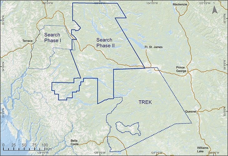
This kind of portrait is called a Magnetic Gradient and Radiometric Survey. In 2016, three magnetometer-equipped Cessna aircraft flew over a 24,000 square kilometre region in west-central B.C., at a line spacing of 250 metres. The equipment they were armed with could record magnetic variations caused by minerals in the upper region of the earth's crust.
These magnetic signatures were mapped and provided data for explorers to analyze and focus their exploration efforts.
What the survey revealed was strong indications of where copper, silver and molybdenum might be, along with other baseline data freely available to the public.
It also fits geographically between similar surveys conducted in the past three years in adjoining areas.
"Search Phase II is the largest geophysical survey ever conducted by Geoscience BC," said Robin Archdekin, president and CEO for Geoscience BC. "The area has well-established infrastructure including reliable road networks, a rail line, accessible hydro, and a skilled workforce, all helping to make this region a cost-effective area to explore and ultimately develop a mine."
No airborne survey in Canada was ever bigger than this effort to map the local subterranean area. All the data is available for the use of local governments, First Nations, environmental groups, businesses and it is especially useful for mining and petroleum companies to help them hone in their explorations more efficiently.
"Mineral exploration is a key driver of our provincial economy," said Energy and Mines Minister Bill Bennett.
"Supporting and growing the mineral exploration sector is vitally important to British Columbia. I am looking forward to the communities along Highway 16 enjoying the spinoff benefits of developing this region.
He added, "this valuable data will help explorers decide where to focus their mining efforts and will eventually lead to on-the-ground exploration activities that will create jobs and stimulate regional economic activity. "
The high-tech and high-ambition science done by Geoscience BC, an independent arm's-length agency operating for the B.C. people at large, as their mandate, has proved to be valuable over recent years. Premier Christy Clark announced that the agency would get $10 million over the next two years to keep at it.
"Public geoscience is integral to the long-term success of the mining industry in B.C. and every single dollar invested is returned five times over to British Columbians," said Clark. "We're also providing tax incentives to make sure that mineral exploration companies choose B.C. as the place to do business. That translates to more family-supporting jobs and grows our economy."
Clark clarified that "every $1 invested in new mining-related public geoscience data attracts $5 in exploration investment, and substantially more with new discoveries. Geoscience information acts as knowledge infrastructure to reduce risk to companies and influences them to choose B.C. over other jurisdictions as a destination for their investment. These investments lead to identifying new mineral resources and ultimately to developing new mines."
"Thank you to Premier Clark and Minister Bennett for providing Geoscience BC with this two-year funding," said Archdekin.
"This funding certainty will ensure that Geoscience BC continues to undertake independent earth-science research that supports government objectives, as well providing investor and public confidence in the mineral and oil and gas sectors."
Archdekin, Bennett and Clark were all in Prince George mid-week for the Premier's B.C. Natural Resources Forum. They were also together the previous week at the annual Roundup Conference held in Vancouver by the Association for Mineral Exploration where some of this information was made public.
It remains to be seen which combination of government officials, private company representatives and independent agencies will converge for the next such gathering, Minerals North, taking place this year in Prince George from April 25-27.
.png;w=120;h=80;mode=crop)

