
Drought conditions in Prince George have now reached Level 5, the most severe level in the B.C. government’s drought ranking system.
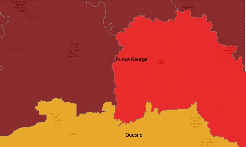
The B.C. Drought Information Portal is reporting Level 5 drought conditions in the Upper Fraser West Basin, which includes the area of the city west of the Fraser River. Under Level 5 conditions, “adverse impacts are almost certain.”
Level 4 conditions are reported in the Upper Fraser East Basin, which includes the portion of the city east of the Fraser River. Under Level 4 conditions, adverse impacts are considered likely.
“Despite scattered showers throughout much of the province on Monday, July 24, 2023, people are urged to be prepared and continue to follow all regional fire prohibitions and local water restrictions due to extreme wildfire risks and the ongoing drought,” a statement issued by the Ministry of Emergency Management and Climate Readiness on Tuesday said. “Despite recent rain, most of the province remains in a Drought Level 4 or Drought Level 5 classification. People, businesses and governments throughout the province are encouraged to continue water conservation efforts.”
Level 5 drought conditions are reported in much of northern B.C., including the Parsnip and Finlay basins north of Prince George, the South Peace and Fort Nelson basins in the northeast, and the Bulkley-Lakes Basin stretching from Terrace to Burns Lake.
South of Prince George, in the Middle Fraser Basin around Quesnel, Drought Level 3 conditions are reported.
The water level on the Fraser River at the South Fort George monitoring station was reported at 5.25 metres as of Tuesday morning, 1.15 m below normal for this time of year. At Shelley, the Fraser River was 1.34 m below normal levels.
The level of the Nechako River at the Isle Pierre monitoring station was 3.06 m, 0.53 m below average.

