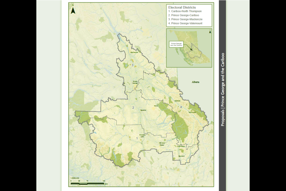
The B.C. Electoral Boundaries Commission is recommending that Prince George be divided into three districts for the next two provincial elections.
The BCEBC’s preliminary report released Tuesday also recommends that B.C. keep all six of its current ridings in the North, with no adjustments to the boundaries, and that the province should add six new electoral districts in Langford, Burnaby, Langley, Surrey, Vancouver and Kelowna – all of which have experienced significant population growth.
B.C. has added close to 300,000 residents in the past five years, which has swelled the province’s population to 5,000,879 in 2022. The proposed electoral map would have 93 electoral districts, up from the current 87.
The new Prince George-Cariboo riding would take in the southern half of the College Heights neighbourhood and Westgate subdivision and would include Quesnel, Wells, Likely, Stoner, Hixon, Soda Creek and Horsefly.
Prince George-Mackenzie would include Cranbrook Hill, Heritage, North Nechako, Hart and Shady Valley neighbourhoods in the city, as well as Mud River, the lakes areas west and northwest of P.G. and would also include Shelley, Salmon Valley, Summit Lake, Bear Lake, McLeod Lake and Mackenzie.
Prince George-Valemount would encompass downtown Prince George, South Fort George, Charella Gardens, northern College Heights, Valemount, McBride, Tete Jaune Cache, Blue River and the northernmost part of the North Thompson River area.
With a current population of 76,708, Prince George is by far the largest city in the region and all four Prince George and Cariboo electoral districts cover sparsely-populated areas.
“Residents in this area consistently emphasized the challenge of ensuring effective representation for people living in rural and remote areas,” the report states. “They highlighted the inadequacy of existing transportation and connectivity infrastructure. Many told us that we should maintain the existing electoral district boundaries. Some said that ensuring adequate representation in growing urban areas should not come at the expense of the residents of this area.
“Transportation is a particular challenge here. The arterial Highways 16, 97 and 20 connect the communities throughout the Cariboo and Chilcotin. They run over a high plateau that is subject to harsh weather conditions year round. Many remote communities depend on these roads and have no alternative routes.
“This area has among the worst connectivity in the province. Although improving, cellular and internet access remains poor outside of major communities. Combining the Cariboo ridings (Prince George–Cariboo and Thompson-Cariboo) would exacerbate these transportation and connectivity problems.”
All 10 electoral districts in the northern half of the province have fewer people than the B.C. average.
The proposed adjustments to the current boundaries of those ridings in the North region are designed to bring the population of each riding within the usual deviation range of the electoral quotient. The quotient is determined by dividing the population of B.C. by the number of electoral districts, which determines the provincial average – 53,773.
Prince George-Valemount, with a population of 43,014 has 20 per cent fewer people. The deviation from the electoral quotient is 23.3 per cent in Prince George-Mackenzie, which has a population of 41,224. The new Prince George-Cariboo district, with a population of 42,080, has a deviation of 21.7 per cent, while in Nechako Lakes, with a population of 25,293, the deviation is 53 per cent.
On the six North region ridings, all but Peace River North fall below the lower limit of 25 per cent less than the provincial quotient. Residents of those areas told the commission of the challenges of geography, which require MLAs to travel great distances to meet with their constituents. Most agreed that reducing the number of electoral districts in the North would undermine effective representation in the legislature. Some of the respondents wanted more ridings to increase their influence in provincial decision-making.
“As our mandate requires, we first asked ourselves whether it was possible to reduce the number of electoral districts in this area and bring each district’s population within the usual deviation range without compromising effective representation. We considered the location of communities, geographical features, transportation corridors and communications.
“Having done so, we concluded that any changes to the existing boundaries of these six electoral districts would deprive their residents of effective representation. Therefore, we propose no changes to their existing boundaries.”
The BCEBC’s final report is due on April 23, 2023. The legislative assembly will then vote to determine which, if any, of the recommendations will be adopted.
The commission will begin public hearings this month to discuss the proposed changes. British Columbians can also provide input by completing an online survey. The deadline for public input is Nov. 22.


