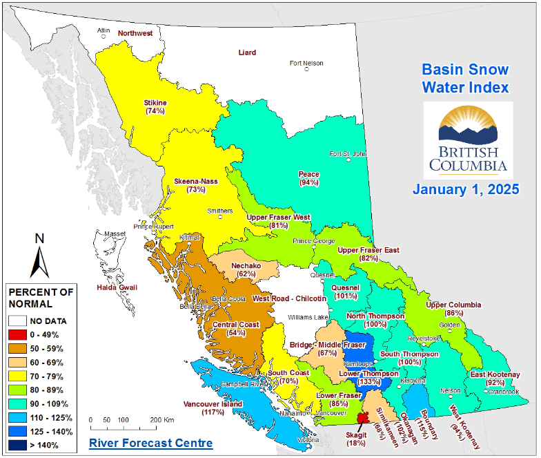
The Upper Fraser East region – which stretches roughly from Valemount to Prince George – is hovering at 82 per cent of its normal snowpack after about three years of drought, according to the latest snow survey and water supply bulletin from the Ministry of Water, Land and Resource Stewardship.
While slightly below normal, the figure is a far cry from last January, when the region sat at 63 per cent of normal. Below normal snowpack may amplify drought in spring and summer, though weather conditions may change and bring more snow before then, the Ministry says.
The rest of the province is enjoying higher snowpack, too. Last year, the provincial average was 56 per cent of normal. This year, the province has an average of 87 per cent of normal snowpack.
Three to four months of snow remain, the bulletin states. During that time, BC may see the effects of La Niña – a term for the phenomenon where cooler than normal waters appear in the Pacific Ocean, as explained on the Environment and Climate Change Canada webpage on the topic. This typically translates to cooler temperatures and more precipitation in BC, according to the ministry.
However, the ministry forecasts above-normal temperatures for January through March. Still, the province may see above-normal precipitation in that period, though precipitation forecasts are difficult to predict at a seasonal scale.
The ministry is set to release eight snow survey and water supply bulletins this year, from January through mid-June. While release dates are subject to change based on data variability, the next bulletin is scheduled for release on Feb. 10 or 11.


