
Wildfire smoke will remain a health hazard for Prince George for at least the next couple days and the city is under a special air quality statement issued by Environment Canada.
So if you want to practice running a marathon or go for an epic bike ride, this might not be the best time to be training outdoors.
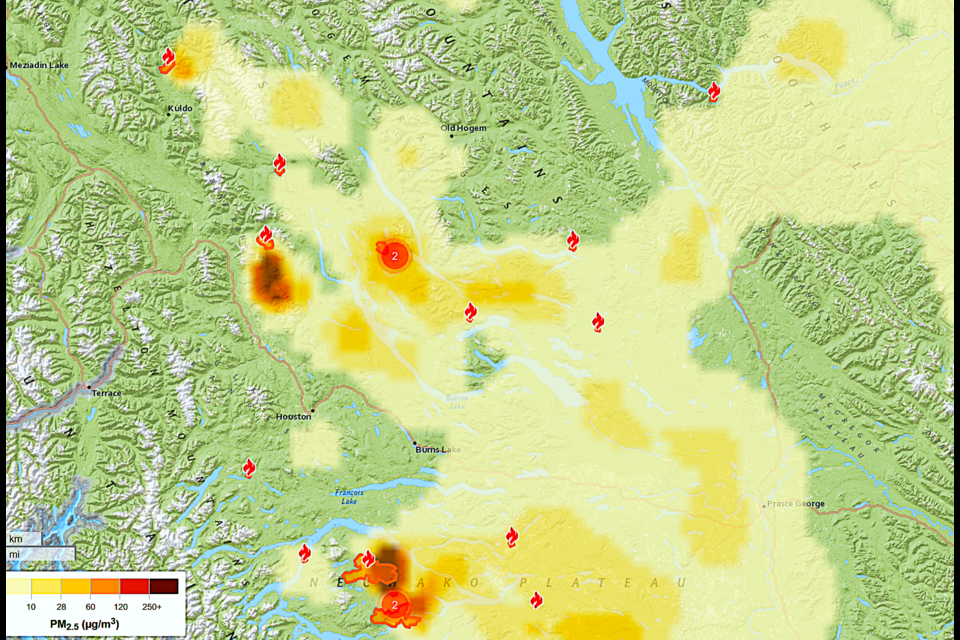
According to FireSmoke.ca, the city was expected to be under a haze for the remainder of Monday with fires burning west and northwest of the city attributed as the source of most of that smoke.
“It does fluctuate little bit and it also depends on wind direction and prevailing winds go from west to east,” said Adam Nicholas, a B.C. Wildfire service fire information officer for the Prince George Fire Centre, who notes that the province’s FireSmoke.ca smoke prediction map forecasts for only the next two days.
“Speaking from personal experience, living in Prince George, I only really noticed the smoke on the weekend. So I’m not sure beyond those two days what the outlook will be for smoke. It’s also obviously helped by things like rain and when the fires burn available vegetation.”
Wildfire smoke is expected to be a factor in the city’s airshed at least for the next couple of days. That’s expected to push fine particulate PPM 2.5 counts into the moderate range (28-60 ppm) at certain times of the day today and Tuesday.
Two large fires are burning near Ootsa Lake, within 36 kilometres of the South Bank community, south of Francoise Lake. One of those fires has grown to 21,842 hectates and the other is estimated at 17,840 ha.
There’s also a cluster of five fires burning out of control northwest of Prince George near Babine Lake, 24 km northeast of the town of Granisle. The largest of the five is 598 ha and is north of MacDougall Creek.
The Regional District of Bulkley Nechako issued an evacuation alert for Laidman Lake, with a 5,335 ha fire burning nearby, one of seven out-of-control fires in the Vanderhoof-Fort St. James zone.
The province currently has 414 active wildfires, six of which are considered fires of note, all in the southern half of the province, including three in the South East Fire Centre (Dogtooth, Komomko Creek and Argenta Creek) and three in the Kamloops Fire Centre (Calcite Creek, Shetland Creek and Hullcar Mountain).
There were 34 new fire starts reported in the last day and 236 new starts in the past seven days, 83 per cent of which were caused by lightning.
After a week of hot and mostly dry weather the North West Fire Centre has reinstated its Category 1 (campfire) ban in all areas except the Cassiar zone. There is no ban on campfires in the Prince George Fire Centre, which encompasses the entire northeast quadrant of B.C., but Category 2 and 3 fires are banned.
Thirty-six fires were declared out in the past 24 hours and 305 were extinguished in the past seven days.
The warm spell will continue through today with a high of 27 C expected, five degrees warmer than the normal high of 22.3 C.
There’s a 30 per cent risk of thundershowers tonight and the clouds are expected to hand around on Tuesday with a predicted high of 22 C and a 40 per cent chance of showers in the afternoon.
A mix of sun and cloud is in the forecast for Wednesday, reaching a high of 22 C and a sunny day is in store for Thursday for the start of the B.C. Northern Exhibition, with a predicted high of 22 C.
For the rest of the week you can expect a cloudy day Friday, with an anticipated high of 20 C, warming to 24 C on Saturday and a steamy 26 C on Sunday.

